Risk assessment, risk analysis and risk management require reliable (high quality) wild population data, which are not available so far. This project, funded by EFSA, is aimed at mapping wildlife species in Europe that are relevant for pathogens transmitted to animals and humans. The objectives that ENETWILD will develop during next phases are focused on wild boar population data for risk assessment regarding African swine fever.
During January 2018 the ENETWILD consortium organized the first Annual General Meeting of the project hold in Parma. This meeting provided a better understanding for the participants of the ENETWILD project, and user input on:
- the future data collection model (DCM) for subsequent submission of data to EFSA of geographic distribution and abundance of wild boar in Europe; where is data?
- the approach to wild boar population data validation and quality assessment criteria
- harmonized collection methods that will be promoted by the project
- enhancing the network for data collection and sharing
- field protocols to estimate wild boar abundance
The presentations and the conclusion of the workshops of the meeting are available at this link
Subsequently, ENETWILD Consortium released a questionnaire to describe hunting statistic collection frameworks across Europe. The main objectives of this questionnaire was to describe how data is collected, so we can promote harmonized data collection in order to make comparable hunting data from different European regions and Countries.
The questionnaire reflects three major pillars underpinning hunting activity and data collection systems; hunters, hunting grounds and game animals. You can download and get more information at this link
The consortium has received a wealth of information from different regions, which will allow us to compare and draw a picture of the existing landscape in Europe on this subject.
Below are maps indicating the different Countries that have sent the completed questionnaire for different data types. We are trying to expand this information to other areas nearby Asia. If you can provide additional information or you can provide us with contact details for the regions for which we do not have information, we welcome you to contact us.
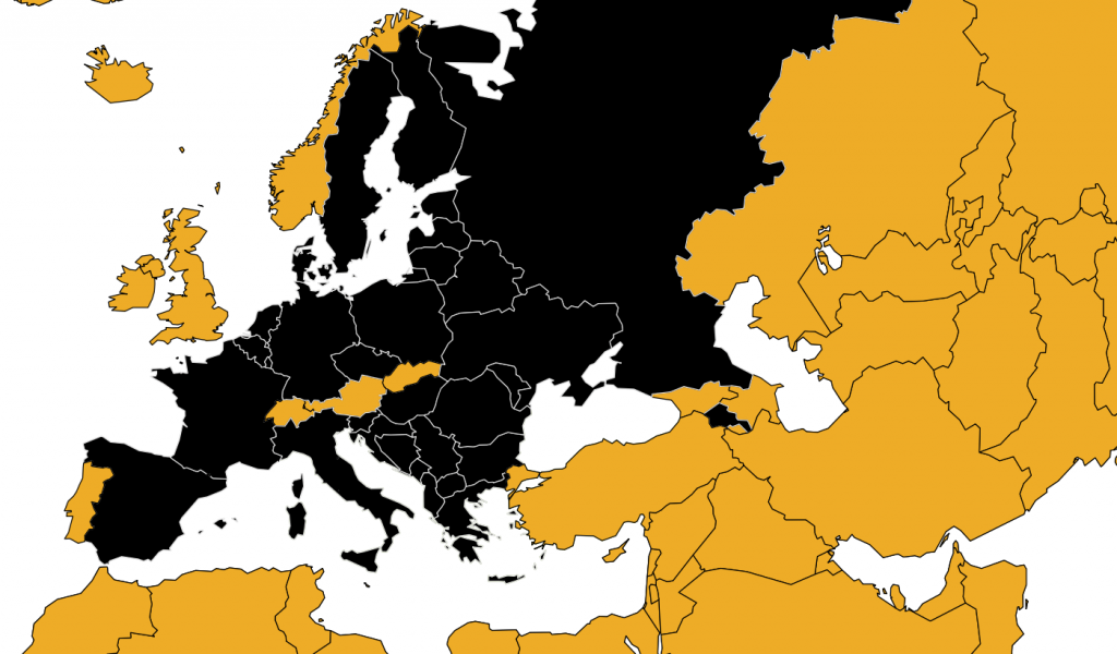
Fig 1. Countries that have sent information on the questionnaire on data collection frameworks for hunting statistics
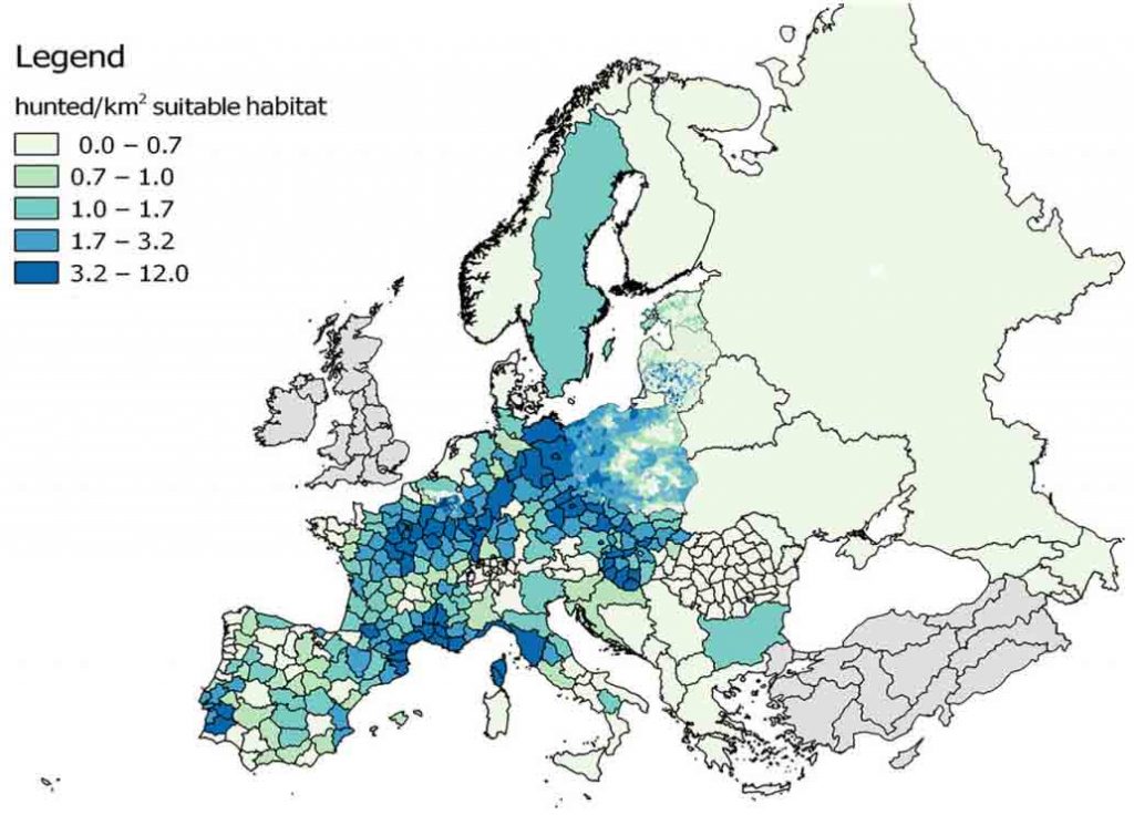
Fig 2. Numbers of wild boar harvested in the hunting grounds in the EU Member States in 2017
However, the project is much more ambitious and ENETWILD is trying to collect information with greater spatial precision for modelling the distribution and abundance of wild boar.
ENETWILD released of a normalized wild boar data model (WBDM) to populate a common database, which later will be validated and shared.
ENETWILD defined the data requested in this model and their technical specifications to offer a common frame to insert them; i.e. what we call the STANDARDS.
The data requested refer to wild boar (i) hunting statistics, (ii) density and (iii) occurrence, including (specially) absence data. Therefore, different data model should be used for each type of data (see links below).
- WBDM_hunting
- WBDM_density
- WBDM_occurrence
You can download, forms, instructions, tutorials and get more information at this link
Many institutions have already provided data on hunting grounds scales, that will be essential to modeling the risks assessment.
“This project keeps updating and incorporating information from new collaborators and new temporal windows”.
So your collaboration will be essential to improve existing information and complement missing data in different regions.
The consortium has received a wealth of information from different regions, which will allow us to compare and draw a picture of the existing landscape in Europe on this subject.
Camera trap data from monitoring programs are more than welcome, including absences records, but also other types of records as road kills, damage to crops by wildlife, etc….

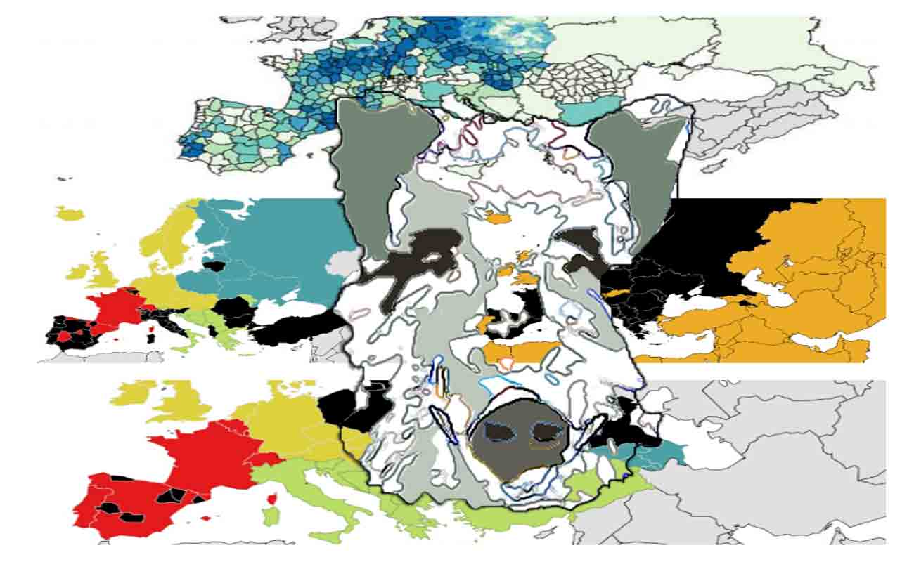
Fig 3. Distribution of the European countries among the ENETWILD regional partners for data collection and quality assessment, South West region (red) coordinate by IREC and ONCFS; South East region (green) coordinate by UNITO and UNISS; North West region (yellow) coordinate by ITAW; North East region (blue) coordinate by MRI
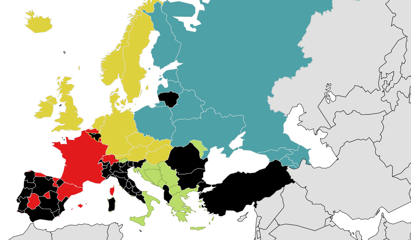
Fig 4. ENETWILD regions in different colors. Black areas are regions which have sent any occurrence records,
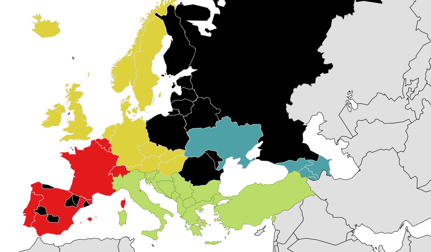
Fig 5. ENETWILD regions for data collection are indicated in different colors. Black areas are regions from which, up to now, we have received local density records.
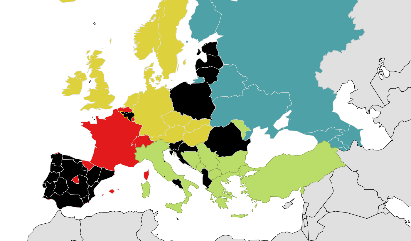
Fig 6. ENETWILD regions for data collection are indicated in different colors. Black areas are regions from which hunting records have been received, at hunting ground or higher spatial resolution than administrative NUTs3 level
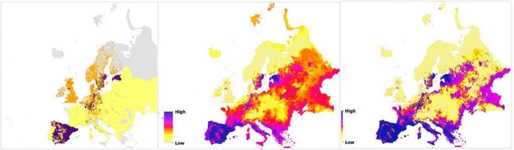
Fig 7. Left to right: suitable GBIF data 2014-2017; wild boar habitat suitability model projection and wild boar relative density proyection.
A map of institutions , which collaborated directly providing or facilitating data submission is coming, and will be published in our website continuously
Institutions collaborating in Wild Boar Data Collection
If your institution does not appear and has collaborated with ENETWILD by sending data, it will probably appear shortly. We are continually updating this information. Remember to send to ENETWILD regional partners information on the links associated with your institution (website, logo, location), to properly highlight your institution